File:Louisiana Population Map.png
en:Category:Louisiana maps
Louisiana state population density map based on Census 2010 data. See the data lineage for a process description.

|
Permission is granted to copy, distribute and/or modify this document under the terms of the GNU Free Documentation License, Version 1.2 or any later version published by the Free Software Foundation; with no Invariant Sections, no Front-Cover Texts, and no Back-Cover Texts. A copy of the license is included in the section entitled GNU Free Documentation License. |
| This file is licensed under the Creative Commons Attribution-Share Alike 3.0 Unported license. | ||
| Attribution: JimIrwin at the English Wikipedia | ||
| ||
| This licensing tag was added to this file as part of the GFDL licensing update. |
Click on a date/time to view the file as it appeared at that time.
| Date/Time | Thumbnail | Dimensions | User | Comment | |
|---|---|---|---|---|---|
| current | 14:11, 11 December 2011 | 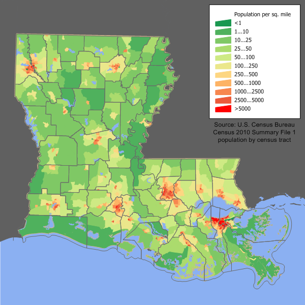 | 600 × 600 (219 KB) | JimIrwin | 2010 census update |
| 19:39, 12 May 2008 |  | 680 × 550 (47 KB) | File Upload Bot (Magnus Manske) | {{BotMoveToCommons|en.wikipedia}} {{Information |Description={{en|en:Category:U.S. State Population Maps en:Category:Louisiana maps Louisiana state population density map based on Census 2000 data. See the [[:en:User:JimIrwin/Lineage_of_popula |
The following other wikis use this file: