Loading
  • 21 Aug, 2019

  • By, Wikipedia

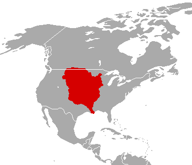
File:Louisiane 1800.png

(All user names refer to fr.wikipedia)

  • 2003-09-01 20:34 F5ZV 412×306×8 (7986 bytes) carte de la Louisiane en 1800 au moment de la vente par Napoléon aux Etats-Unis.

Captions

Add a one-line explanation of what this file represents

Items portrayed in this file

depicts

18 August 2010

File history

Click on a date/time to view the file as it appeared at that time.

Date/TimeThumbnailDimensionsUserComment
current00:57, 16 December 2010Thumbnail for version as of 00:57, 16 December 2010383 × 329 (9 KB)Maps & Lucyfixed the border along New Spain and changed colour to Spanish Red due to it being a territory of New Spain
15:14, 18 August 2010Thumbnail for version as of 15:14, 18 August 2010383 × 329 (9 KB)Maps & Lucy{{Information |Description=''English:'' The Louisiana Territory as it was from 1763 to 1803. <br> ''Français:'' La Louisiane territoire comme il a été de 1763 à 1803. <br> ''Español:'' La Louisiana Territorio como lo fue desde 1763 a 1803. |Source=[[
11:23, 29 January 2007Thumbnail for version as of 11:23, 29 January 2007412 × 306 (8 KB)Bilou~commonswiki{{Information |Description=carte de la Louisiane en 1800 au moment de la vente par Napoléon aux États-Unis. |Source=Dessinée par F5ZV |Date=2003-09-01 (original upload date) |Author=F5ZV at [http://fr.wikipedi
The following pages on the English Wikipedia use this file (pages on other projects are not listed):

Global file usage

The following other wikis use this file: