File:Maoke Plate Map-fr.png
Click on a date/time to view the file as it appeared at that time.
| Date/Time | Thumbnail | Dimensions | User | Comment | |
|---|---|---|---|---|---|
| current | 23:00, 18 November 2006 | 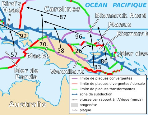 | 476 × 370 (263 KB) | Rémih | {{Information |Description={{fr|Carte de la plaque de Maoke}}{{en|Map of the Maoke Plate}} |Source=Cropped version by myself of Image:Tectonic_plates_boundaries_detailed-fr.svg created by Sting under CC-BY-SA |Date=18/11/2006 |Author=[ |
File usage
The following pages on the English Wikipedia use this file (pages on other projects are not listed):
Global file usage
The following other wikis use this file:
- Usage on az.wikipedia.org
- Usage on ca.wikipedia.org
- Usage on es.wikipedia.org
- Usage on eu.wikipedia.org
- Usage on fr.wikipedia.org
- Usage on id.wikipedia.org
- Usage on it.wikipedia.org
- Usage on ja.wikipedia.org
- Usage on ko.wikipedia.org
- Usage on pl.wikipedia.org
- Usage on ru.wikipedia.org
- Usage on uk.wikipedia.org
- Usage on zh.wikipedia.org