Loading
  • 21 Aug, 2019

  • By, Wikipedia

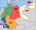
File:Map-Germany-1945.svg

Transferred from en.wikipedia to Commons by Broadbeer using CommonsHelper.

The original description page was here. All following user names refer to en.wikipedia.
  • 2008-03-17 19:50 52 Pickup 3492×2966× (760290 bytes) Changes to fill and border colours. Made differences clearer between occupation zones and eventual territorial losses.
  • 2007-08-31 14:57 52 Pickup 3492×2966× (755561 bytes) New version: regions placed under Polish and Soviet administration now presented slightly differently (borders instead of colour fill), Saar colour now only slightly different to French zone (still needs some work)
  • 2007-08-10 09:50 52 Pickup 3492×2966× (751829 bytes) oops, now with fixed image size
  • 2007-08-10 09:47 52 Pickup 744×1052× (751774 bytes) {{Information| |Description= Germany in the aftermath of World War II: 1 September 1945 |Source= Based on map data of the IEG-Maps project (Andreas Kunz, B. Johnen and Joachim Robert Moeschl: University of Mainz) - [http://www.ieg-maps.uni-mainz.de www.ie
Annotations
InfoField
This image is annotated: View the annotations at Commons

Captions

Occupation map of Germany after WW2

Items portrayed in this file

depicts

17 March 2008

File history

Click on a date/time to view the file as it appeared at that time.

Date/TimeThumbnailDimensionsUserComment
current04:37, 1 December 2017Thumbnail for version as of 04:37, 1 December 20173,492 × 2,966 (726 KB)SammimackUpdated flags and colours
14:13, 3 July 2015Thumbnail for version as of 14:13, 3 July 20153,492 × 2,966 (728 KB)LichaoshengNew 48-Star US Flag from File:US flag 48 stars.svg
14:00, 3 July 2015Thumbnail for version as of 14:00, 3 July 20153,492 × 2,966 (742 KB)LichaoshengReverted to version as of 18:46, 8 October 2008
15:19, 4 February 2012Thumbnail for version as of 15:19, 4 February 20123,492 × 2,966 (742 KB)AnonMoosReverted to version as of 18:46, 8 October 2008 -- Kaliningrad had quite different status and fate from that of East Germany proper...
19:44, 20 January 2012Thumbnail for version as of 19:44, 20 January 20123,492 × 2,966 (742 KB)Sammy pomponKaliningrado is occuped by USSR.
18:46, 8 October 2008Thumbnail for version as of 18:46, 8 October 20083,492 × 2,966 (742 KB)File Upload Bot (Magnus Manske) {{BotMoveToCommons|en.wikipedia}} {{Information |Description={{en|Occupation zone borders in Germany, 1947. The territories east of the en:Oder-Neisse line, under Polish and Soviet administration/annexation, are shown as white as is the likewise det

Global file usage

The following other wikis use this file:

View more global usage of this file.

Metadata