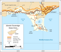
File:Map Of Akrotiri-en.svg
Click on a date/time to view the file as it appeared at that time.
| Date/Time | Thumbnail | Dimensions | User | Comment | |
|---|---|---|---|---|---|
| current | 09:39, 10 June 2010 |  | 1,035 × 886 (189 KB) | Mysid | font change |
| 09:36, 10 June 2010 |  | 1,035 × 886 (189 KB) | Mysid | {{Information |Description={{en|1=Map of the Akrotiri Sovereign Base Area in Cyprus.}} |Source=Self-made in Inkscape. Borders based on CIA World Factbook. Some map data (roads) © OpenStreetMap contributors, CC-BY-SA. |Author=Mysid |Date= |
File usage
The following 7 pages use this file:
Global file usage
The following other wikis use this file:
- Usage on cs.wikipedia.org
- Usage on fr.wikipedia.org
- Usage on ja.wikipedia.org
- Usage on ko.wikipedia.org
- Usage on nl.wikipedia.org
- Usage on no.wikipedia.org
- Usage on pt.wikipedia.org
- Usage on ru.wikipedia.org
- Usage on uk.wikipedia.org
- Usage on zh.wikipedia.org