File:Map Of Ancient Rome 271 AD.svg
[]
-
 català
 -
 English
 -
 français
 -
 hrvatski
 -
 Latina
 -
 magyar
 -
 Bahasa Indonesia
 -
 Nederlands
 -
 polski
 -
 português
 -
 suomi
suomi -
 српски (ћирилица)
 -
 հայերեն
 -
 文言
文言 -
 العربية
 -
 עברית
עברית -
 русский


.svg)


|
This SVG file contains embedded text that can be translated into your language, using any capable SVG editor, text editor or the SVG Translate tool. For more information see: About translating SVG files. |
Licensing

|
Permission is granted to copy, distribute and/or modify this document under the terms of the GNU Free Documentation License, Version 1.2 or any later version published by the Free Software Foundation; with no Invariant Sections, no Front-Cover Texts, and no Back-Cover Texts. A copy of the license is included in the section entitled GNU Free Documentation License. Subject to disclaimers. |
Original upload log
The original description page was here. All following user names refer to en.wikipedia.
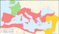
- 2007-11-07 02:47 Justinian43 524×377×8 (26490 bytes) The Mediterranean by 271 A.D -The [[Roman Empire]]. -The breakaway [[Gallic Empire]]. -The breakaway [[Palmyrene Empire]].
- derivative work: Pomalee (talk)
other_versions=Derivative works of this file: Map of Ancient Rome 271 AD-sr.svg Permission= GNU Free Documentation License, Version 1.2, Creative Commons Attribution-ShareAlike license versions 3.0, 2.5, 2.0, and 1.0
- Romanworld271AD.jpg: User:Justinian43, uploaded by User:El_bes
| This is a retouched picture, which means that it has been digitally altered from its original version. Modifications: Used "Blank_map_of_South_Europe_and_North_Africa.svg" to refashion "Romanworld271.jpg". The original can be viewed here: Romanworld271AD.jpg:
|

|
Permission is granted to copy, distribute and/or modify this document under the terms of the GNU Free Documentation License, Version 1.2 or any later version published by the Free Software Foundation; with no Invariant Sections, no Front-Cover Texts, and no Back-Cover Texts. A copy of the license is included in the section entitled GNU Free Documentation License. |
| This file is licensed under the Creative Commons Attribution-Share Alike 3.0 Unported license. | ||
| ||
| This licensing tag was added to this file as part of the GFDL licensing update. |
Original upload log
This image is a derivative work of the following images:
- File:Blank_map_of_South_Europe_and_North_Africa.svg licensed with Cc-by-sa-2.5,2.0,1.0, GFDL
- 2007-08-09T20:26:49Z Historicair 2050x1213 (1260388 Bytes)
- 2007-08-09T16:12:00Z Historicair 2050x1213 (351130 Bytes) {{Improving}} {{Information |Description={{fr}}Carte vierge de l'Europe du Sud et du Bassin Méditerranée dans l'Antiquité {{en}}Blank map of South Europe and North Africa at Antic period |Source=Own work + [[Image:Blank map of South Europe and North Africa.svg]] by myself
- File:Romanworld271AD.jpg licensed with GFDL-en
- 2007-11-20T15:23:56Z El bes 524x377 (26490 Bytes) {{Information |Description= The Roman Empire around the year 271 AD, with the break awai Gallic Empire in the West |Source= http://en.wikipedia.org/key/Image:Romanworld271AD.JPG |Date= November 20th, 2007 |Author= [[http://e
Uploaded with derivativeFX


