File:Map Of Lydia Ancient Times-en.svg
Original picture:
Author
Other versions
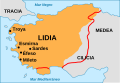
- Info from these maps:
- Map 1 (brown):
- "middle of the 6th century at the time of King Croesus"
- Map 2 (red line):
- "7th C. BCE roughly from 690 to 546 BCE"
SVG picture:
- Original: User:Roke
- SVG: User:Nekto
- English: User:WillemBK
[]
-
 Alemannisch (.svg)
 -
 Deutsch (.jpg)
 -
 Deutsch (.svg)
 -
 English (.jpg)
 -
 English (.svg)
 -
 español (.svg)
 -
 Esperanto (.svg)
 -
 Frysk (.svg)
 -
 italiano (.svg)
 -
 Latina (.svg)
 -
 Nederlands (.svg)
 -
 português (.svg)
 -
 Türkçe (.svg)
 -
 Ελληνικά (.svg)
 -
 беларуская (.svg)
 -
 русский (.svg)
 -
 հայերեն (.svg)
 -
 日本語 (.svg)
 -
 한국어 (.svg)
 -
 文言 (.png)
 -
 فارسی (.svg)


|
This SVG file contains embedded text that can be translated into your language, using any capable SVG editor, text editor or the SVG Translate tool. For more information see: About translating SVG files. |
Licensing
This file is licensed under the Creative Commons Attribution-Share Alike 3.0 Unported license.
- You are free:
- to share – to copy, distribute and transmit the work
- to remix – to adapt the work
- Under the following conditions:
- attribution – You must give appropriate credit, provide a link to the license, and indicate if changes were made. You may do so in any reasonable manner, but not in any way that suggests the licensor endorses you or your use.
- share alike – If you remix, transform, or build upon the material, you must distribute your contributions under the same or compatible license as the original.
