File:Map Of Lydia Ancient Times.jpg
Info from these maps:
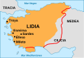
Map 1 (brown):
"middle of the 6th century at the time of King Croesus"
Author
Other versions
Map 2 (red line): "7th C. BCE roughly from 690 to 546 BCE"
- User:Roke (Own work)
[]
-
 Alemannisch (.svg)
 -
 Deutsch (.jpg)
 -
 Deutsch (.svg)
 -
 English (.jpg)
 -
 English (.svg)
 -
 español (.svg)
 -
 Esperanto (.svg)
 -
 Frysk (.svg)
 -
 italiano (.svg)
 -
 Latina (.svg)
 -
 Nederlands (.svg)
 -
 português (.svg)
 -
 Türkçe (.svg)
 -
 Ελληνικά (.svg)
 -
 беларуская (.svg)
 -
 русский (.svg)
 -
 հայերեն (.svg)
 -
 日本語 (.svg)
 -
 한국어 (.svg)
 -
 文言 (.png)
 -
 فارسی (.svg)


|
File:Map of Lydia ancient times-en.svg is a vector version of this file. It should be used in place of this JPG file when not inferior.
File:Map of Lydia ancient times.jpg → File:Map of Lydia ancient times-en.svg
For more information, see Help:SVG. |
 |
Licensing

|
Permission is granted to copy, distribute and/or modify this document under the terms of the GNU Free Documentation License, Version 1.2 or any later version published by the Free Software Foundation; with no Invariant Sections, no Front-Cover Texts, and no Back-Cover Texts. A copy of the license is included in the section entitled GNU Free Documentation License. |
| This file is licensed under the Creative Commons Attribution-Share Alike 3.0 Unported license. | ||
| ||
| This licensing tag was added to this file as part of the GFDL licensing update. |
