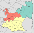
File:Map Of Mpumalanga With Districts Shaded And Municipalities Numbered (2016).svg
Click on a date/time to view the file as it appeared at that time.
| Date/Time | Thumbnail | Dimensions | User | Comment | |
|---|---|---|---|---|---|
| current | 23:21, 7 September 2016 |  | 768 × 746 (372 KB) | Htonl | == {{int:filedesc}} == {{Information |Description ={{en|1=Map of the municipalities in Mpumalanga province of South Africa, with district municipalities shaded and local municipalities numbered with their MDB codes.}} |Source ={{own}}; based... |
File usage
The following pages on the English Wikipedia use this file (pages on other projects are not listed):
- Albert Luthuli Local Municipality
- Albert Luthuli Local Municipality elections
- Bushbuckridge Local Municipality
- Bushbuckridge Local Municipality elections
- Dipaleseng Local Municipality
- Dipaleseng Local Municipality elections
- Dr JS Moroka Local Municipality
- Dr JS Moroka Local Municipality elections
- Ehlanzeni District Municipality
- Emakhazeni Local Municipality
- Emakhazeni Local Municipality elections
- Emalahleni Local Municipality, Mpumalanga
- Emalahleni Local Municipality, Mpumalanga elections
- Gert Sibande District Municipality
- Govan Mbeki Local Municipality
- Govan Mbeki Local Municipality elections
- Lekwa Local Municipality
- Lekwa Local Municipality elections
- List of municipalities in Mpumalanga
- Mbombela Local Municipality
- Mbombela Local Municipality elections
- Mkhondo Local Municipality
- Mkhondo Local Municipality elections
- Msukaligwa Local Municipality
- Msukaligwa Local Municipality elections
- Nkangala District Municipality
- Nkomazi Local Municipality
- Nkomazi Local Municipality elections
- Pixley ka Seme Local Municipality
- Pixley ka Seme Local Municipality elections
- Steve Tshwete Local Municipality
- Steve Tshwete Local Municipality elections
- Thaba Chweu Local Municipality
- Thaba Chweu Local Municipality elections
- Thembisile Hani Local Municipality
- Thembisile Hani Local Municipality elections
- Umjindi Local Municipality
- Victor Khanye Local Municipality
- Victor Khanye Local Municipality elections
- Template:Municipal elections in Mpumalanga
- Template:Municipalities of Mpumalanga
Global file usage
The following other wikis use this file:
- Usage on de.wikipedia.org