File:Map Of Perry County Pennsylvania School Districts.png
Click on a date/time to view the file as it appeared at that time.
| Date/Time | Thumbnail | Dimensions | User | Comment | |
|---|---|---|---|---|---|
| current | 21:20, 21 June 2006 | 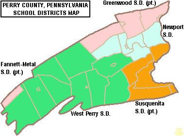 | 379 × 281 (10 KB) | Ruhrfisch | {{Information| |Description= Map of Perry County, Pennsylvania, United States Public School Districts |Source= taken from US Census website [http://factfinder.census.gov/] and modified by User:Ruhrfisch |Date= June 2006 |Author= US Census, Ruhrfisch |
| 20:15, 5 June 2006 |  | 379 × 281 (12 KB) | Ruhrfisch | {{Information| |Description= Map of Perry County, Pennsylvania, United States Public School Districts |Source= taken from US Census website [http://factfinder.census.gov/] and modified by User:Ruhrfisch |Date= June 2006 |Author= US Census, Ruhrfisch |
File usage
The following 11 pages use this file:
- Carson Long Military Academy
- Fannett-Metal School District
- Greenwood School District (Pennsylvania)
- Newport High School (Pennsylvania)
- Newport School District (Pennsylvania)
- Susquenita High School
- Susquenita School District
- West Perry High School
- West Perry School District
- Template:Perry County, Pennsylvania School Districts
- Category:School districts in Perry County, Pennsylvania
Global file usage
The following other wikis use this file:
- Usage on ja.wikipedia.org