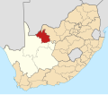
File:Map Of South Africa With John Taolo Gaetsewe Highlighted (2011).svg
Click on a date/time to view the file as it appeared at that time.
| Date/Time | Thumbnail | Dimensions | User | Comment | |
|---|---|---|---|---|---|
| current | 04:41, 14 May 2011 |  | 809 × 709 (507 KB) | Htonl | == Summary == {{Information |Description ={{en|1=Map of district boundaries in South Africa, as they will be after the municipal elections of 18 May 2011, with the [[w:John Taolo Gaetsewe District Municipali |
File usage
The following 14 pages use this file:
Global file usage
The following other wikis use this file:
- Usage on af.wikipedia.org
- Kuruman
- Hotazel
- Dingleton
- Kathu
- Olifantshoek
- Van Zylsrus
- Dibeng
- Sjabloonbespreking:Suid-Afrikaanse distriksmunisipaliteit navbox
- Mothibistad
- Heuningvlei
- Cassel
- Dithakong
- Bankhara
- Havard, Noord-Kaap
- Gamopedi
- Ga-Ntatelang
- Maruping
- Sedibeng, Noord-Kaap
- Phakane
- Seoding
- Ntsweng
- Mamoratwe
- Maheane
- Magobe
- West Derby
- Usage on bg.wikipedia.org
- Usage on ceb.wikipedia.org
- Usage on ha.wikipedia.org
- Usage on id.wikipedia.org
- Usage on ig.wikipedia.org
- Usage on lv.wikipedia.org
- Usage on nso.wikipedia.org
- Mmasepala Setereke tša John Taolo Gaetsewe
- Template:John Taolo Gaetsewe District Municipality
- Mmušôgaê wa Gamagara
- Mmušôgaê wa Joe Morolong
- Mmušôgaê wa Ga-Segonyana
- Kuruman
- Mothibistad
- Van Zylsrus
- Hotazel
- Heuningvlei
- Dithakong
- Cassel
- Dingleton
- Dibeng, Kapa Leboa
- Kathu
- Olifantshoek
- Bankhara
- Gamopedi
- Ga-Ntatelang
View more global usage of this file.