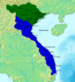
File:Map Of Southern And Northern Dynasties Of Vietnam.png
Click on a date/time to view the file as it appeared at that time.
| Date/Time | Thumbnail | Dimensions | User | Comment | |
|---|---|---|---|---|---|
| current | 11:17, 19 May 2020 |  | 650 × 800 (124 KB) | A | Upload a to a new name if you want, but don't replace files of other people |
| 00:54, 17 May 2020 |  | 764 × 843 (694 KB) | Zhu Zi Ling | Cities and town added | |
| 19:14, 29 September 2015 |  | 650 × 800 (124 KB) | Denniss | Reverted to version as of 17:11, 25 December 2014 | |
| 13:04, 28 September 2015 |  | 650 × 800 (82 KB) | 昭文館 | =={{int:filedesc}}== {{Information |description={{en|1=Vietnam circa 1570 showing the Mac in control of the land north of the Red river, and the Nguyen-Trinh alliance in control of the southern part of Vietnam. Map data based on "The Empire of Le Than... | |
| 17:11, 25 December 2014 |  | 650 × 800 (124 KB) | TRMC | User created page with UploadWizard |
File usage
The following pages on the English Wikipedia use this file (pages on other projects are not listed):
Global file usage
The following other wikis use this file:
- Usage on bn.wikipedia.org
- Usage on ceb.wikipedia.org
- Usage on de.wikipedia.org
- Usage on fr.wikipedia.org
- Usage on id.wikipedia.org
- Usage on it.wikipedia.org
- Usage on ja.wikipedia.org
- Usage on ko.wikipedia.org
- Usage on sl.wikipedia.org
- Usage on uk.wikipedia.org
- Usage on vi.wikipedia.org
- Usage on www.wikidata.org
- Usage on zh.wikipedia.org