Loading
  • 21 Aug, 2019

  • By, Wikipedia

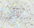
File:Map Of Medieval Parish Churches Of York - All Saints, Pavement.svg

The ODbL does not require any particular license for maps produced from ODbL data. Prior to 1 August 2020, map tiles produced by the OpenStreetMap Foundation were licensed under the CC-BY-SA-2.0 license. Maps produced by other people may be subject to other licences.

Kartenwerkstatt
This map has been made or improved in the German Kartenwerkstatt (Map Lab). You can propose maps to improve as well.

Captions

Add a one-line explanation of what this file represents

Items portrayed in this file

depicts

14 February 2013

File history

Click on a date/time to view the file as it appeared at that time.

Date/TimeThumbnailDimensionsUserComment
current20:35, 14 February 2013Thumbnail for version as of 20:35, 14 February 20131,086 × 906 (1.42 MB)NordNordWest== {{int:filedesc}} == {{Information |Description= {{de|Karte der mittelalterlichen Pfarrkirchen in York, All Saints, Pavement, hervorgehoben, Namen in Grau: Gebäude nicht mehr existent}} {{en|Map of the medieval parish churches of York, All Saints, P...
The following pages on the English Wikipedia use this file (pages on other projects are not listed):

Global file usage

The following other wikis use this file:

Metadata