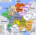
File:Map Of The Imperial Circles (1512)-en.png
en:User:Silverhelm is the author of this image file.
Its contents are based in part on a map published in the "Historical Atlas" by Prof. William R Shepherd, pub. Henry Holt & Co. (New York, 1911).
Other versions:
[]


1512
-
 български (PNG)
 -
 català
 -
 Deutsch (PNG)
 -
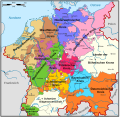
 English (PNG)
 -
 español
 -
 français
 -
 magyar (PNG)
-bg.png)
-ca.svg&lang=ca)
-de.png)
-en.png)
-es.svg)
-fr.svg)
.png)
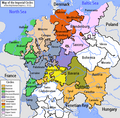
1560
-
 català
 -
 Deutsch
 -
 English (original)
 -
 español
 -
 Latina
 -
 Nederlands
-ca.svg&lang=ca)
-de.svg)
-en.svg)
-es.svg)
-la.svg)
-nl.svg)
derivative works
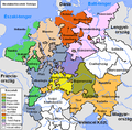
Derivative works of this file: Map of the Imperial Circles (1512)-bg.png
Licensing
This file is licensed under the Creative Commons Attribution-Share Alike 2.5 Generic license.
- You are free:
- to share – to copy, distribute and transmit the work
- to remix – to adapt the work
- Under the following conditions:
- attribution – You must give appropriate credit, provide a link to the license, and indicate if changes were made. You may do so in any reasonable manner, but not in any way that suggests the licensor endorses you or your use.
- share alike – If you remix, transform, or build upon the material, you must distribute your contributions under the same or compatible license as the original.

-en.png)
-en.png)