Click on a date/time to view the file as it appeared at that time.
| Date/Time | Thumbnail | Dimensions | User | Comment |
|---|
| current | 16:00, 7 October 2016 | 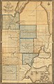 | 8,298 × 12,772 (27.75 MB) | TimK MSI | {{Information |Description ={{en|1=Map of the surveyed part of the territory of Michigan / by O. Risdon ; engraved by Rawdon, Clark & Co. Originally published: [Albany, N.Y.] : [O. Risdon], 1825. Scan of a map in the collection of the Michigan Sta... |
The following pages on the English Wikipedia use this file (pages on other projects are not listed):
This file contains additional information, probably added from the digital camera or scanner used to create or digitize it.
If the file has been modified from its original state, some details may not fully reflect the modified file.


