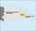
File:Mapa De La Colonia De Santo Domingo Durante La Ocupación Francesa.png
Click on a date/time to view the file as it appeared at that time.
| Date/Time | Thumbnail | Dimensions | User | Comment | |
|---|---|---|---|---|---|
| current | 22:50, 25 August 2016 |  | 4,664 × 3,984 (405 KB) | Bettyreategui | User created page with UploadWizard |
File usage
The following 2 pages use this file:
Global file usage
The following other wikis use this file:
- Usage on es.wikipedia.org