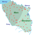
File:Mara And Mondrem.png
Click on a date/time to view the file as it appeared at that time.
| Date/Time | Thumbnail | Dimensions | User | Comment | |
|---|---|---|---|---|---|
| current | 08:50, 9 May 2010 |  | 800 × 804 (100 KB) | Espresso Addict | Minor change to shading |
| 08:20, 9 May 2010 |  | 800 × 804 (100 KB) | Espresso Addict | {{Information |Description={{en|1=Sketch map of the forests of Mara and Mondrem (at a date between 1277 & 1536). Red dot: township within the forest; F: Frodsham; T: Tarporley; U: Utkinton; VR: Vale Royal Abbey; W: Weaverham. }} |Source={{own}} |Author=[[ |
File usage
The following 2 pages use this file: