File:Matagorda Bay Texas 1689.JPG
This work is in the
public domain in its country of origin and other countries and areas where the
copyright term is the author's
life plus 70 years or fewer.
 You must also include a United States public domain tag to indicate why this work is in the public domain in the United States.
 Note that a few countries have copyright terms longer than 70 years: Mexico has 100 years, Jamaica has 95 years, Colombia has 80 years, and Guatemala and Samoa have 75 years. This image may
not be in the public domain in these countries, which moreover do
not implement the
rule of the shorter term. Honduras has a general copyright term of 75 years, but it
does implement the rule of the shorter term. Copyright may extend on works created by French who died for France in
World War II (
more information), Russians who served in
the Eastern Front of World War II (known as the Great Patriotic War in Russia) and posthumously
rehabilitated victims of Soviet repressions (
more information).
| This file has been identified as being free of known restrictions under copyright law, including all related and neighboring rights.
|
https://creativecommons.org/publicdomain/mark/1.0/PDMCreative Commons Public Domain Mark 1.0falsefalse
Click on a date/time to view the file as it appeared at that time.
| Date/Time | Thumbnail | Dimensions | User | Comment |
|---|
| current | 01:38, 12 February 2008 | 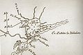 | 917 × 602 (67 KB) | Karanacs | {{Information |Description=This is a map of Matagorda Bay, Texas as of 1689. The map was drawn by Carlos de Sigüenza y Góngora based on sketches compiled during the expedition of Alonso de Leon. The Spanish called the bay "Lago de San Bernardo". An F |
The following pages on the English Wikipedia use this file (pages on other projects are not listed):
The following other wikis use this file:
- Usage on ar.wikipedia.org
- Usage on ca.wikipedia.org
- Usage on cs.wikipedia.org
- Usage on en.wikivoyage.org
- Usage on eo.wikipedia.org
- Usage on es.wikipedia.org
- Usage on fr.wikipedia.org
- Usage on it.wikipedia.org
- Usage on ja.wikipedia.org
- Usage on ru.wikipedia.org
- Usage on www.wikidata.org
- Usage on zh.wikipedia.org
This file contains additional information, probably added from the digital camera or scanner used to create or digitize it.
If the file has been modified from its original state, some details may not fully reflect the modified file.
