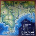
File:Mazunte Area Map.jpg
The photographical reproduction of this work is covered under the article 148, VII of the Mexican copyright law (Ley Federal de Derechos de Autor), which states that
«Literary and artistic works already published may be used, provided that normal commercialization of the work is not affected, without authorization from the copyrightholder and without remuneration, invariably citing the source and without altering the work, only in the following cases: […]
VII. Reproduction, communication, and distribution by means of drawings, paintings, photographs, and audiovisual means of works visible from public places». See COM:CRT/Mexico#Freedom of panorama for more information.
| This work has been released into the public domain by its author, Fsamuels. This applies worldwide. In some countries this may not be legally possible; if so: |
Original upload log
Transferred from en.wikipedia to Commons using FtCG.
The original description page was here. All following user names refer to en.wikipedia.
| Date/Time | Dimensions | User | Comment |
|---|---|---|---|
| 05:33, 1 August 2006 | 1,536 × 1,536 (279,735 bytes) | w:en:Fsamuels (talk | contribs) | (A map of Mazunte located at the Tourist Information area. The picture was taken on July 6, 2006.<br> ~~~~) |
