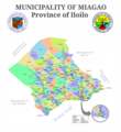
File:Miagao Map With Roads And Labels.png
Click on a date/time to view the file as it appeared at that time.
| Date/Time | Thumbnail | Dimensions | User | Comment | |
|---|---|---|---|---|---|
| current | 12:52, 15 September 2023 |  | 2,000 × 2,176 (751 KB) | Retdar | |
| 11:51, 14 December 2021 |  | 1,805 × 1,505 (236 KB) | Retdar | Updated town shape with the one used by the International Red Cross and the Mines and Geosciences Bureau | |
| 05:40, 24 September 2014 |  | 1,708 × 1,428 (240 KB) | Retdar | User created page with UploadWizard |
File usage
The following pages on the English Wikipedia use this file (pages on other projects are not listed):
Global file usage
The following other wikis use this file:
- Usage on incubator.wikimedia.org
- Usage on ja.wikipedia.org