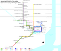
File:Miami Metro Map 2017.png
Click on a date/time to view the file as it appeared at that time.
| Date/Time | Thumbnail | Dimensions | User | Comment | |
|---|---|---|---|---|---|
| current | 05:17, 16 January 2018 |  | 5,500 × 4,600 (835 KB) | FrickFrack | Update for actual 2018 service |
| 11:13, 11 October 2016 |  | 5,500 × 4,600 (836 KB) | FrickFrack | Minor cleanup edits to last edition | |
| 10:52, 11 October 2016 |  | 5,500 × 4,600 (836 KB) | FrickFrack | Made recommended southwestward bend in Metrorail alignment south of Brickell and Douglas Road stations, per suggestion. Moved title to top-left to avoid clutter at the bottom of the diagram. | |
| 12:28, 3 October 2016 |  | 5,500 × 4,600 (822 KB) | FrickFrack | Updated to include recommended map changes, updated legend with regular spacing between symbols, adding additional symbols for updates. Uniform fonts for all stations. Replaced spokes at single-service station to dots uniformly. | |
| 04:50, 2 October 2016 |  | 4,962 × 4,205 (806 KB) | B137 | Add basic BRT busway line with no station detail. True BRT is increasingly being accepted as virtual light rail, and is a critical feeder to the Dadeland end of Metrorail. | |
| 02:08, 1 October 2016 |  | 4,962 × 4,205 (797 KB) | B137 | Add Amtrak services | |
| 01:55, 1 October 2016 |  | 4,962 × 4,205 (795 KB) | B137 | Add en:MIA Mover | |
| 13:10, 30 September 2016 |  | 4,962 × 4,205 (714 KB) | FrickFrack | User created page with UploadWizard |
File usage
The following pages on the English Wikipedia use this file (pages on other projects are not listed):
Global file usage
The following other wikis use this file:
- Usage on da.wikipedia.org
- Usage on en.wikivoyage.org
- Usage on eo.wikipedia.org
- Usage on fa.wikipedia.org
- Usage on id.wikipedia.org
- Usage on it.wikivoyage.org
- Usage on no.wikipedia.org
- Usage on tr.wikipedia.org
- Usage on www.wikidata.org
- Usage on zh.wikipedia.org