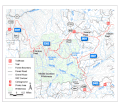
File:Middle Santiam Wilderness Map.gif
Click on a date/time to view the file as it appeared at that time.
| Date/Time | Thumbnail | Dimensions | User | Comment | |
|---|---|---|---|---|---|
| current | 22:22, 2 August 2011 |  | 520 × 446 (109 KB) | Jsayre64 | {{Information |Description ={{en|1=Map of the Middle Santiam Wilderness and surroundings in Linn County, Oregon, United States}} |Source =[http://www.fs.usda.gov/wps/portal/fsinternet/!ut/p/c4/04_SB8K8xLLM9MSSzPy8xBz9CP0os3gDfxMDT8MwRydLA1cj72B |
File usage
The following pages on the English Wikipedia use this file (pages on other projects are not listed):