Click on a date/time to view the file as it appeared at that time.
| Date/Time | Thumbnail | Dimensions | User | Comment |
|---|
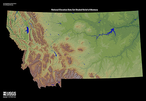
| current | 19:31, 23 November 2008 |  | 500 × 345 (70 KB) | AlexiusHoratius~commonswiki | {{Information |Description={{en|1=Shaded relief map of the U.S. state of Montana. From the United States Geological Survey.}} |Source=http://eros.usgs.gov/imagegallery/index.php/collection/ned_states |Author=United States Geological Survey |Date= |Permiss |
The following pages on the English Wikipedia use this file (pages on other projects are not listed):
The following other wikis use this file:
- Usage on bg.wikipedia.org
- Usage on el.wikipedia.org
- Usage on fy.wikipedia.org
- Usage on is.wikipedia.org
- Usage on ja.wikipedia.org
- Usage on pam.wikipedia.org
- Usage on sah.wikipedia.org
- Usage on zh.wikipedia.org
This file contains additional information, probably added from the digital camera or scanner used to create or digitize it.
If the file has been modified from its original state, some details may not fully reflect the modified file.