Click on a date/time to view the file as it appeared at that time.
| Date/Time | Thumbnail | Dimensions | User | Comment |
|---|
| current | 16:06, 18 May 2012 | 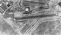 | 511 × 292 (125 KB) | Cobatfor | == {{int:filedesc}} == {{Information |Description=Aerial photo of the U.S. Navy Naval Air Facility Litchfield Park, Arizona (USA), in 1950. NAF Litchfield Park was used to store aircraft until 1968 when all U.S. military aircraft were stored at Davis-M... |
The following page uses this file:
The following other wikis use this file:
- Usage on ja.wikipedia.org
