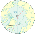
File:Nansen's Planned Drift Map.svg
Click on a date/time to view the file as it appeared at that time.
| Date/Time | Thumbnail | Dimensions | User | Comment | |
|---|---|---|---|---|---|
| current | 22:36, 12 October 2009 |  | 496 × 490 (1.29 MB) | Lokal Profil | Cleaned up code a bit |
| 22:24, 12 October 2009 |  | 496 × 490 (1.52 MB) | Lokal Profil | Removed FlowPath and added "Greenland" which seemed to be what the intention had been. | |
| 19:44, 12 October 2009 |  | 496 × 490 (1.52 MB) | Niagara | experiment | |
| 19:34, 12 October 2009 |  | 496 × 490 (1.53 MB) | Niagara | fix | |
| 19:30, 12 October 2009 |  | 496 × 490 (1.52 MB) | Niagara | fix | |
| 19:28, 12 October 2009 |  | 496 × 490 (1.48 MB) | Niagara | {{Information |Description = Map of the planned drift to the North Pole and beyond in Nansen's ''Fram'' expedition |Source = Heavily modified version of File:Artide.svg |Date = 2009-10-12 |Author = Dtb |
File usage
The following page uses this file:
Global file usage
The following other wikis use this file:
- Usage on be.wikipedia.org
- Usage on ca.wikipedia.org
- Usage on da.wikipedia.org
- Usage on en.wikibooks.org
- Usage on es.wikipedia.org
- Usage on fr.wikipedia.org
- Usage on hy.wikipedia.org
- Usage on it.wikipedia.org
- Usage on ja.wikipedia.org
- Usage on no.wikipedia.org
- Usage on pt.wikipedia.org
- Usage on ro.wikipedia.org
- Usage on ru.wikipedia.org
- Usage on uk.wikipedia.org
- Usage on zh.wikipedia.org