File:NezavisnaDrzavaHrvatska.png
Click on a date/time to view the file as it appeared at that time.
| Date/Time | Thumbnail | Dimensions | User | Comment | |
|---|---|---|---|---|---|
| current | 20:21, 26 November 2014 | 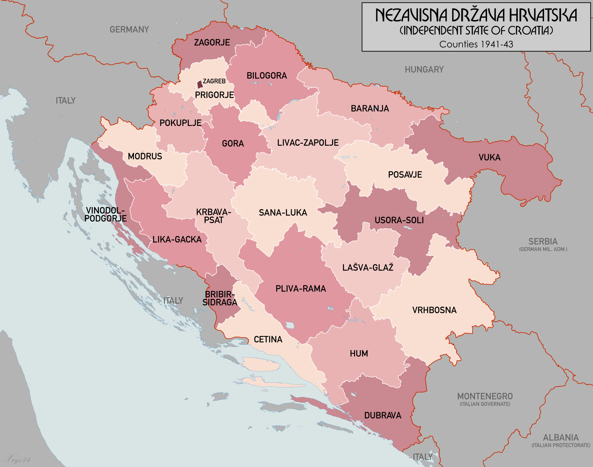 | 2,000 × 1,576 (643 KB) | XrysD | New font. |
| 15:32, 22 November 2014 |  | 2,000 × 1,576 (656 KB) | XrysD | Completely new version. Source data from Volkstumskarte von Jugoslawien 1:200k (Wilfried Krallert) Wien (1941). | |
| 22:56, 13 September 2011 |  | 1,780 × 1,580 (209 KB) | XrysD | Harmonised with other versions of the map. | |
| 22:33, 24 July 2011 |  | 890 × 749 (94 KB) | XrysD | Reverted to version as of 12:05, 11 October 2008 | |
| 10:10, 2 June 2011 |  | 890 × 749 (100 KB) | DIREKTOR | Simpler color scheme. | |
| 12:05, 11 October 2008 |  | 890 × 749 (94 KB) | XrysD | {{Information |Description=Counties of the Independent State of Croatia in 1941 |Source= |Date= |Author= |Permission= |other_versions= }} | |
| 09:18, 19 August 2008 |  | 660 × 592 (161 KB) | XrysD | {{Information |Description=Administrative Map of the Independent State of Croatia (Nezavisna Drzava Hrvatska) |Source=self-made |Date=19-08-2008 |Author= XrysD |Permission= |other_versions= }} |
File usage
The following pages on the English Wikipedia use this file (pages on other projects are not listed):
Global file usage
The following other wikis use this file:
- Usage on ast.wikipedia.org
- Usage on bs.wikipedia.org
- Usage on cs.wikipedia.org
- Usage on eo.wikipedia.org
- Usage on es.wikipedia.org
- Usage on fr.wikipedia.org
- Usage on hr.wikipedia.org
- Nezavisna Država Hrvatska
- Upravna podjela NDH
- Mraclin
- Velika župa Baranja
- Velika župa Hum
- Velika župa Dubrava
- Velika župa Prigorje
- Velika župa Vinodol-Podgorje
- Velika župa Vrhbosna
- Predložak:Velike župe u NDH
- Velika župa Zagorje
- Velike župe u NDH
- Velika župa Cetina
- Velika župa Bilogora
- Velika župa Vuka
- Velika župa Posavje
- Velika župa Livac-Zapolje
- Velika župa Gora
- Velika župa Gora-Prigorje
- Velika župa Pokupje
- Velika župa Modruš
- Velika župa Lika-Gacka
- Velika župa Bribir-Sidraga
- Velika župa Bribir
- Velika župa Sidraga-Ravni Kotari
- Velika župa Lašva-Glaž
- Velika župa Raša
- Velika župa Krbava-Psat
- Velika župa Pliva i Rama
- Velika župa Usora-Soli
- Velika župa Sana-Luka
- Velika župa Lašva-Pliva
- Kotari u NDH
- Suradnik:Imbehind/NDH
- Usage on it.wikipedia.org
- Usage on ja.wikipedia.org
- Usage on lt.wikipedia.org
- Usage on pt.wikipedia.org
View more global usage of this file.