File:North Sea Languages 900.png
This is part of the commons-picture Image:Old norse, ca 900.PNG focused on the North Sea.
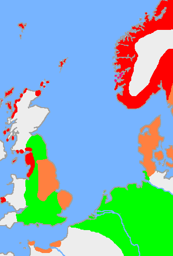
This is the approximate extent of Old Norse and related languages in the early 10th century around the North Sea. The red area is the distribution of the dialect Old West Norse, the orange area is the spread of the dialect Old East Norse and the green area is the extent of the other Germanic languages with which Old Norse still retained some mutual intelligibility
w:User:Wiglaf made the original map, based on Image:Europe plain rivers.png, a blank map by User:Dbachmann.
Sources:Nationalencyklopedin and The Harper Atlas of World History (ed. Vidal-Naquet) in Swedish translation: Atlas över mänsklighetens historia.
Uploaded to en: by Wiglaf on April 20, 2005 and licensed under GFDL.
| This file is licensed under the Creative Commons Attribution-Share Alike 3.0 Unported license. Subject to disclaimers. | ||
| ||
| This licensing tag was added to this file as part of the GFDL licensing update. |

|
Permission is granted to copy, distribute and/or modify this document under the terms of the GNU Free Documentation License, Version 1.2 or any later version published by the Free Software Foundation; with no Invariant Sections, no Front-Cover Texts, and no Back-Cover Texts. A copy of the license is included in the section entitled GNU Free Documentation License. Subject to disclaimers. |
