File:Orbis Typus Uniuersalis Iuxta Hydrographorum Traditionem - Norman B. Leventhal Map Center At The BPL.jpg
Zoom into this map at maps.bpl.org.
Author: Waldseemèuller, Martin
Publisher: Johannes Schott
Date: 1513.
Location: America
Date
Source
Orbis typus uniuersalis iuxta hydrographorum traditionem
Author
http://maps.bpl.org
Other versions
Scale: Scale not given. Call Number: G3200 1513.W3
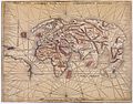
Waldseemèuller may have had second thoughts about his 1507 proposal for naming the new continent "America." In 1513, he issued a fourth publication, a new edition of Claudius Ptolemy's Geographia. In it he included contemporary world and regional maps as well as the traditional 27 found in the first printed versions of the Geographia. Surprisingly, his "modern world map" is not a reduced version of his original 1507 map of the world. Waldseemueller's 1513 map, often referred to as the "Admiral's Map," reportedly reflects Columbus's interpretation of the New World discoveries. Consequently, the map focuses on the Caribbean islands and northern South America, which is placed at the map's western margins with no indication of a western coastline. The name "America" is excluded in this updated world map. Substantiating this retraction is another map in the same volume. On the regional map of the Caribbean and Atlantic Ocean (Tabula Terre Nove), South America is labeled "Terra Incognita" (unknown land) and bears an inscription indicating that these lands were discovered by Columbus, with no indication of Amerigo Vespucci's role in the exploration of the northern coast of South America.| Martin Waldseemüller
(1470–) |
|||
|---|---|---|---|
 |
|||
| Alternative names |
Martin Hylacomylus | ||
| Description | cartographer, cosmographer, theologian and geographer | ||
| Date of birth/death | circa 1470 |
16 March 1520 / 1521 | |
| Location of birth/death | Wolfenweiler bei Freiburg im Breisgau | Saint-Dié-des-Vosges | |
| Work period | 1500 | ||
| Work location | |||
| Authority file | |||
-
 1513 Waldseemueller
 -
 1522 Fries
 -
 1522 Fries
 -
 1525 Fries
 -
 1525 Fries
 -
 1541 Fries


Licensing
This file is licensed under the Creative Commons Attribution 2.0 Generic license.
- You are free:
- to share – to copy, distribute and transmit the work
- to remix – to adapt the work
- Under the following conditions:
- attribution – You must give appropriate credit, provide a link to the license, and indicate if changes were made. You may do so in any reasonable manner, but not in any way that suggests the licensor endorses you or your use.
| This image was originally posted to Flickr by Norman B. Leventhal Map Center at the BPL at https://www.flickr.com/photos/24528911@N05/2710790498. It was reviewed on 2 July 2012 by FlickreviewR and was confirmed to be licensed under the terms of the cc-by-2.0. |
