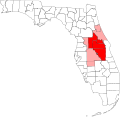
File:Orlando-Kissimmee Florida Metropolitan Statistical Area.svg
Click on a date/time to view the file as it appeared at that time.
| Date/Time | Thumbnail | Dimensions | User | Comment | |
|---|---|---|---|---|---|
| current | 05:22, 4 July 2019 |  | 1,001 × 970 (112 KB) | Floridian | Updated map to reflect new boundaries of the Orlando-Lakeland-Deltona, FL Combined Statistical Area (addition of Lakeland-Winter Haven, FL Metropolitan Statistical Area and Wauchula, FL Micropolitan Statistical Area). Edited using Method of Action web editor. |
| 15:21, 10 October 2007 |  | 1,001 × 970 (252 KB) | Shereth | == Summary == {{Information |Description=Map of Florida showing the Orlando-Kissimmee Florida Metropolitan Statistical Area highlighted in red, along with the rest of the Orland | |
| 15:20, 10 October 2007 |  | 1,001 × 970 (252 KB) | Shereth | == Summary == {{Information |Description=Map of Florida showing the Orlando-Kissimmee Florida Metropolitan Statistical Area highlighted in red, along with the rest of the Orland | |
| 15:20, 10 October 2007 |  | 1,001 × 970 (252 KB) | Shereth | == Summary == {{Information |Description=Map of Florida showing the Orlando-Kissimmee Florida Metropolitan Statistical Area highlighted in red, along with the rest of the Orland |
File usage
More than 100 pages use this file. The following list shows the first 100 pages that use this file only. A full list is available.
- Addition Financial Arena
- AdventHealth
- AdventHealth Celebration
- AdventHealth Daytona Beach
- AdventHealth Heart of Florida
- AdventHealth Lake Wales
- AdventHealth Nicholson Center
- AdventHealth Orlando
- AdventHealth Palm Coast Parkway
- Alafaya, Florida
- Altamonte Springs, Florida
- Azalea Park, Florida
- Buenaventura Lakes, Florida
- Camping World Stadium
- Casselberry, Florida
- Celebration, Florida
- Central Florida Future
- Clermont, Florida
- Conway, Florida
- Daytona State College
- DeBary, Florida
- DeLand, Florida
- DeLand Municipal Airport
- Deltona, Florida
- Dr. Phillips, Florida
- Dr. Phillips Center for the Performing Arts
- Eustis, Florida
- FBC Mortgage Stadium
- Fairview Shores, Florida
- Florida Today
- Four Corners, Florida
- Goldenrod, Florida
- Greater Orlando
- Holy Land Experience
- Horizon West, Florida
- Hunter's Creek, Florida
- Kia Center
- Kissimmee, Florida
- Kissimmee Gateway Airport
- Lady Lake, Florida
- Lake Butler, Orange County, Florida
- Lake County, Florida
- Lake Mary, Florida
- Lake Nona Medical City
- Lake–Sumter State College
- Leesburg, Florida
- List of AdventHealth hospitals
- Lockhart, Florida
- Longwood, Florida
- Maitland, Florida
- Meadow Woods, Florida
- Mount Dora, Florida
- Oak Ridge, Florida
- Ocoee, Florida
- Orange City, Florida
- Orange County, Florida
- Orlando, Florida
- Orlando Executive Airport
- Orlando Eye
- Orlando Health
- Orlando International Airport
- Orlando International Airport Intermodal Terminal
- Orlando Museum of Art
- Orlando Sanford International Airport
- Orlando Science Center
- Orlando Sentinel
- Osceola News-Gazette
- Oviedo, Florida
- Palm Coast, Florida
- Pine Castle, Florida
- Pine Hills, Florida
- Poinciana, Florida
- Sanford, Florida
- Seminole County, Florida
- Seminole State College of Florida
- Southchase, Florida
- Spook Hill
- St. Cloud, Florida
- Tavares, Florida
- The Daytona Beach News-Journal
- The Villages, Florida
- The Villages Daily Sun
- Timeline of Orlando, Florida
- University, Orange County, Florida
- University of Central Florida
- Valencia College
- WESH
- WFTV
- WKCF
- WKMG-TV
- WOFL
- WRBW
- WUCF-TV
- Wekiwa Springs, Florida
- Windermere, Florida
- Winter Garden, Florida
- Winter Park, Florida
- Winter Springs, Florida
- User:Catfurball/AdventHealth Lakeland
- User:Jasap/sandbox
View more links to this file.
Global file usage
The following other wikis use this file:
- Usage on de.wikipedia.org
- Usage on es.wikipedia.org
- Usage on fa.wikipedia.org
- Usage on fr.wikipedia.org
- Usage on it.wikivoyage.org
- Usage on ru.wikipedia.org
- Usage on ur.wikipedia.org
- Usage on www.wikidata.org