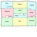
File:Orleans County (New York) - Towns And Villages.svg
Click on a date/time to view the file as it appeared at that time.
| Date/Time | Thumbnail | Dimensions | User | Comment | |
|---|---|---|---|---|---|
| current | 21:46, 11 November 2008 |  | 1,500 × 1,100 (28 KB) | LtPowers | change village labels to condensed and increase point size accordingly |
| 21:38, 11 November 2008 |  | 1,500 × 1,100 (28 KB) | LtPowers | reduce lower margin | |
| 21:27, 11 November 2008 |  | 1,500 × 1,500 (28 KB) | LtPowers | {{Information |Description={{en|1=Map of Orleans County, New York, showing its constituent towns and villages. Labels in English.}} |Source=Own work by uploader, based on public domain USGS topographic maps |Author=[[User:L |
File usage
The following pages on the English Wikipedia use this file (pages on other projects are not listed):
- Barre Center, New York
- Childs, New York
- East Gaines, New York
- Hulberton, New York
- Kent, Orleans County, New York
- Knowlesville, New York
- Lakeside Beach State Park
- Millers, New York
- Millville, New York
- Oak Orchard, New York
- Oak Orchard State Marine Park
- Orleans County, New York
- Sawyer, Orleans County, New York
- Waterport, New York
- Template:OrleansCountyNY-geo-stub
Global file usage
The following other wikis use this file:
- Usage on es.wikipedia.org
- Usage on fr.wikipedia.org
- Usage on ja.wikipedia.org
- Usage on nl.wikipedia.org
- Usage on www.wikidata.org