Loading
  • 21 Aug, 2019

  • By, Wikipedia

File:Oxia Palus Erosion.JPG

Transferred from en.wikipedia to Commons by Magnus Manske using CommonsHelper.

The original description page was here. All following user names refer to en.wikipedia.
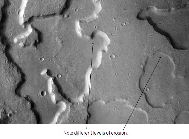
  • 2009-01-16 19:54 Jimmarsmars 640×472× (43677 bytes) {{Information |Description=Oxia Palus erosion. Location is 2.4 degrees north latitude and 16.4 degrees west longitude. |Source=http://themis.la.asu.edu/zoom-20031202a.html |Date=January 16, 2009 |Author=Jim Secosky modified NASA image. |Permission= |othe

Captions

Add a one-line explanation of what this file represents

Items portrayed in this file

depicts

16 January 2009

File history

Click on a date/time to view the file as it appeared at that time.

Date/TimeThumbnailDimensionsUserComment
current08:59, 20 February 2011Thumbnail for version as of 08:59, 20 February 2011640 × 472 (43 KB)File Upload Bot (Magnus Manske) {{BotMoveToCommons|en.wikipedia|year={{subst:CURRENTYEAR}}|month={{subst:CURRENTMONTHNAME}}|day={{subst:CURRENTDAY}}}} {{Information |Description={{en|Oxia Palus erosion. Location is 2.4 degrees north latitude and 16.4 degrees west longitude.}} |Source=
The following pages on the English Wikipedia use this file (pages on other projects are not listed):

Global file usage

The following other wikis use this file:

Metadata