File:PIA16157-MarsCuriosityRover-GoulburnLinkHottah-20120927.jpg
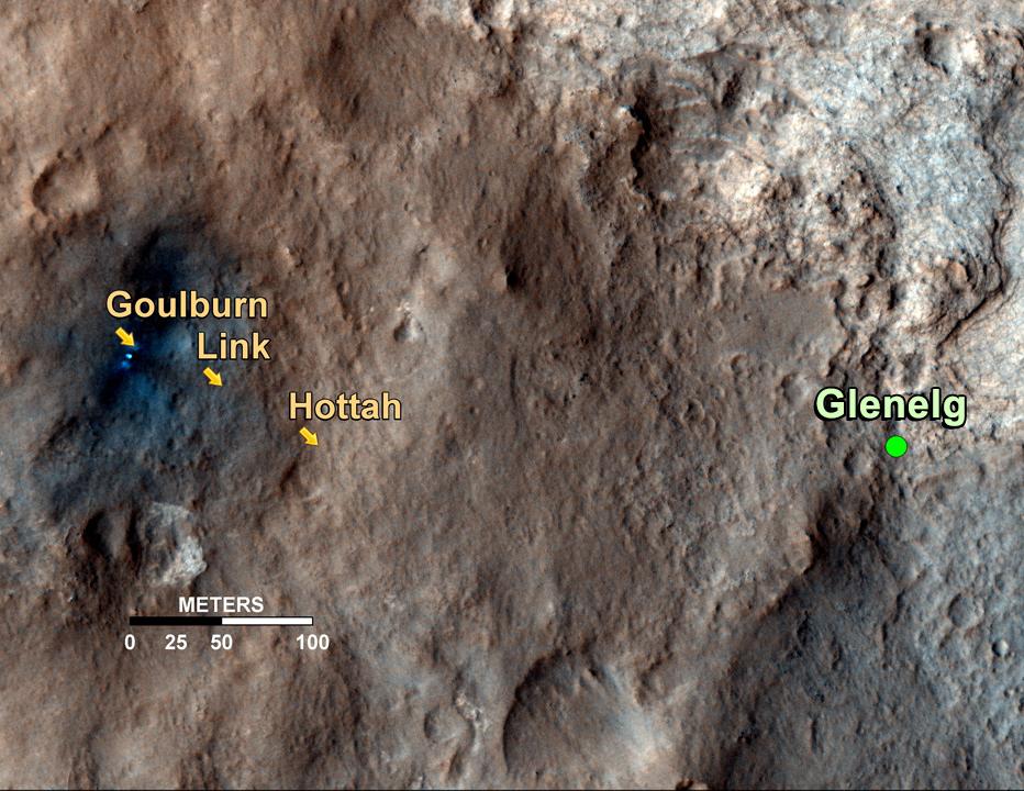
Mapa pokazuje trasę po powierzchni Marsa, należącego do NASA łazika Curiosity, do obszaru Glenelg, na którym to obszarze, z naukowego punktu zainteresowania, zbiegają się trzy różne tereny. Strzałki wskazują napotkane do tej pory miejsca, których geologiczne cechy, doprowadziły do odkrycia czegoś, co wydaje się być dawnym marsjańskim potokiem. Pierwsze miejsce, nazwane Goulburn, jest obszarem, w którym silniki członu zniżania łazika odrzuciły warstwę luźnego materiału, odsłaniając podłoże skalne. Goulburn dał naukowcom wskazówkę, że woda może transportować kamienie piaskowca, z którego to materiału składa się odkrywka. Inne miejsce, naturalnie odkryte podłoże skalne nazwane Link, zwracające uwagę zespołu naukowego, ze względu na osadzone w nim owalne konglomeraty żwiru. Takie zaokrąglone kształty są mocnymi dowodami transportu siłą nurtu wody. Ostatni dowód, inne naturalnie odkryte podłoże skalne nazwane Hottah, zaproponował bardziej przekonujące dowody istnienia w przeszłości strumienia, ponieważ zawiera liczne zaokrąglone kamyki. Wielkości ziaren są również ważną częścią dowodów na istnienie nurtu wody: zaokrąglone kamyki, które mają średnicę do 4 cm, są zbyt duże, aby mogłyby być transportowane przez wiatr.
Obraz użyty do wykonania mapy pochodzi z obserwacji lądowiska przez teleskop zwierciadlany HiRISE instrument znajdujący się na pokładzie należącego NASA do orbitera Mars Reconnaissance Orbiter.
Mapka posiada adnotację wskazującą położenie miejsca lądowania nazywane Bradbury Landing. Kliknij aby adnotację uruchomić.

