Click on a date/time to view the file as it appeared at that time.
| Date/Time | Thumbnail | Dimensions | User | Comment |
|---|
| current | 00:36, 3 June 2020 | 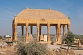 | 6,262 × 4,175 (12.16 MB) | A.Savin | {{User:A.Savin/F|L=0 |Description= {{en|Chaukhandi Necropolis near Karachi, Pakistan}} {{ru|Некрополь Чауханди недалеко от Карачи, Пакистан}} |Year=2020 |Country=Pakistan |Month=02 |Day=02}} {{Location|24|51|59.2|N|67|16|27.2|E|region:PK-SD}} Category:Taken with Sony ILCE-7RM3 Category:Taken with Sony FE 24-105mm F4 G OSS Category:Chaukhandi tombs Category:Mausoleums in Pakistan Category:Columns in Pakistan |
The following pages on the English Wikipedia use this file (pages on other projects are not listed):
This file contains additional information, probably added from the digital camera or scanner used to create or digitize it.
If the file has been modified from its original state, some details may not fully reflect the modified file.
