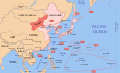
File:Pacific Area - The Imperial Powers 1939 - Map.svg
The borders for this map are primarily based on World2Hires_filled_mercator.svg and Image:Pacific_Area_-_The_Imperial_Powers_1939_-_Map.jpg, but some changes have been made based off information from other sources. Please edit the file if you have access to better information.
Author
Other versions
- The border of Manchukuo are based off Manchuria.jpg.
- The border of Portuguese East Timor is based off LocationEastTimor.svg.
- The border of Mengjiang is based off BlankMap-World 1939.png and The_location_of_Mengjiang_(as_done_in_glorious_mspaint).PNG.
- The borders of Tibet, China and Singkiang are based off the National Geographic "China Map 1945" and China_old_map_1936.jpg.
Derivative works of this file:
-
 Pacific Area
 -
 Korea
Korea -
 Manchukuo
 -
 Mengjiang


[]
-
 català
 -
English
-
 English alt
 -
 español
 -
 Deutsch
 -
 italiano
 -
 magyar
 -
 македонски
 -
 русский
 -
 中文
中文


SVG Support
This document is in the Scalable Vector Graphic format (SVG) and requires a supported browser (Firefox, Google Chrome, Opera) or a SVG plugin for Internet Explorer and other browsers. SVG is an open source format, which means this map can be downloaded and modified/translated completely using a vector graphics editor like Adobe Illustrator or Inkscape (free) or a text editor such as Notepad.
| BLANK THUMBNAIL | View large PNG | View medium PNG | SVG Plugin for Internet Explorer and other browsers |
|---|---|---|---|
| Click here (purge cache) and then CTRL+F5 to reload. Help? | Try 1 Try 2 | Try 1 Try 2 | Adobe SVG plugin |
| Recommended browser | More Help | ||
| Firefox | List of SVG tools |
I, the copyright holder of this work, hereby publish it under the following licenses:
This file is licensed under the Creative Commons Attribution-Share Alike 3.0 Unported license.
- You are free:
- to share – to copy, distribute and transmit the work
- to remix – to adapt the work
- Under the following conditions:
- attribution – You must give appropriate credit, provide a link to the license, and indicate if changes were made. You may do so in any reasonable manner, but not in any way that suggests the licensor endorses you or your use.
- share alike – If you remix, transform, or build upon the material, you must distribute your contributions under the same or compatible license as the original.

|
Permission is granted to copy, distribute and/or modify this document under the terms of the GNU Free Documentation License, Version 1.2 or any later version published by the Free Software Foundation; with no Invariant Sections, no Front-Cover Texts, and no Back-Cover Texts. A copy of the license is included in the section entitled GNU Free Documentation License. |
You may select the license of your choice.
Original upload log
This image is a derivative work of the following images:
- Image:World2Hires_filled_mercator.svg licensed with Cc-by-sa-3.0, GFDL
- 2008-08-03T06:38:19Z Emok 220x171 (12002488 Bytes) {{Information |Description= |Source= |Date= |Author= |Permission= |other_versions={{DerivativeVersions|Pacific Area - The Imperial Powers 1939 - Map - ru.svg}} }} [[Category:Blank SVG maps of the world]]
- 2008-08-03T06:00:29Z Emok 520x519 (3064180 Bytes) {{Information |Description={{en|1=A Pacific-centered Mercator projection of the world with countries filled.}} |Source=Own work by uploader |Author=[[User:Emok|Emok]] |Date=2008-08-01 |Permission= |other_versions={{DerivativeVersions|Pacific Area - The Imperial Powers 1939 - Map - ru.svg}} }} {{Image
- Image:Pacific_Area_-_The_Imperial_Powers_1939_-_Map.jpg
Uploaded with derivativeFX


.PNG)