Click on a date/time to view the file as it appeared at that time.
| Date/Time | Thumbnail | Dimensions | User | Comment |
|---|
| current | 22:31, 11 January 2010 | 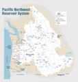 | 1,930 × 2,032 (412 KB) | Spankston | larger file, higher resolution |
| 21:56, 11 January 2010 |  | 914 × 963 (565 KB) | Spankston | {{Information |Description={{en|1=Maps of dams, drainage and estuaries along the Columbia River in North America (USA, Canada). Original caption: The Columbia River carved the Interior Columbia River Basin from the landscape of seven Western states a |
The following other wikis use this file:
- Usage on bg.wikipedia.org
- Usage on de.wikipedia.org
- Usage on fi.wikipedia.org
- Usage on fr.wikipedia.org
- Usage on fy.wikipedia.org
- Usage on he.wikipedia.org
- Usage on it.wikipedia.org
- Usage on nl.wikipedia.org
- Usage on no.wikipedia.org
- Usage on ro.wikipedia.org
- Usage on ru.wikipedia.org
- Usage on vec.wikipedia.org

