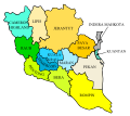
File:Pahang Electoral District.svg
This map shows the parliamentary districts, not administrative districts, of Pahang.
Click on a date/time to view the file as it appeared at that time.
| Date/Time | Thumbnail | Dimensions | User | Comment | |
|---|---|---|---|---|---|
| current | 06:35, 12 March 2008 |  | 600 × 533 (389 KB) | Tebu.an | |
| 05:19, 11 March 2008 |  | 600 × 533 (389 KB) | Tebu.an | ||
| 04:36, 11 March 2008 |  | 600 × 500 (385 KB) | Tebu.an | ||
| 04:28, 11 March 2008 |  | 860 × 700 (358 KB) | Tebu.an | {{Information |Description={{en|Map of district in Pahang's state, {{flagicon|Malaysia}} Malaysia.}}{{ms|Peta daerah dalam negeri Pahang, {{flagicon|Malaysia}} Malaysia.}} |Source=self-made |Date=11 March 2008 |Author= Tebu.an |Permission |