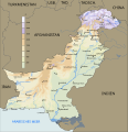
File:Pakistan Geography De.svg
Click on a date/time to view the file as it appeared at that time.
| Date/Time | Thumbnail | Dimensions | User | Comment | |
|---|---|---|---|---|---|
| current | 12:58, 13 December 2015 |  | 819 × 847 (314 KB) | Furfur | again ... |
| 12:56, 13 December 2015 |  | 819 × 847 (326 KB) | Furfur | SVG cleanup | |
| 12:49, 13 December 2015 |  | 1,637 × 1,693 (308 KB) | Furfur | {{Information |Description={{de|1=Topgrafische Karte von Pakistan mit den de facto-Grenzen in Jammu und Kashmir.}} |Source={{Derived from|Pakistan_geography_en.svg|display=40}} Modifications: attached the Siachen glacier to India (de facto under Indian... |
File usage
The following 2 pages use this file:
Global file usage
The following other wikis use this file:
- Usage on ar.wikipedia.org
- Usage on sd.wikipedia.org