Click on a date/time to view the file as it appeared at that time.
| Date/Time | Thumbnail | Dimensions | User | Comment |
|---|
| current | 15:17, 22 March 2019 |  | 636 × 599 (65 KB) | Claude Zygiel | This file in clearly definite as "Map of the British Mandate of Palestine '''and''' Transjordan" and used for the both territories |
| 12:01, 24 October 2017 |  | 636 × 599 (61 KB) | Nicola Romani | Reverted to version as of 11:02, 22 April 2016 (UTC) |
| 17:04, 30 August 2017 | 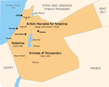 | 675 × 542 (51 KB) | Onceinawhile | Converted into new svg - this is the png version |
| 16:07, 19 October 2016 |  | 636 × 599 (65 KB) | Claude Zygiel | This file in clearly definite as "Map of the British Mandate of Palestine '''and''' Transjordan" and used for the both territories. |
| 11:02, 22 April 2016 |  | 636 × 599 (61 KB) | Makeandtoss | oops |
| 11:01, 22 April 2016 | 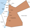 | 636 × 599 (61 KB) | Makeandtoss | Removed Mandatory Palestine since picture is used to refer to only the emirate |
| 15:49, 4 December 2011 |  | 636 × 599 (66 KB) | Wickey-nl | thicker lining around lake |
| 21:43, 3 December 2011 |  | 636 × 599 (66 KB) | Wickey-nl | Fixed border |
| 15:29, 29 January 2011 | 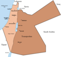 | 636 × 599 (77 KB) | Vadac | Fixed border of Transjordan within the Mandate of Palestine with Saudi Arabia per the present border having been drawn in 1965 as seen here. |
| 11:29, 24 February 2006 |  | 636 × 599 (89 KB) | Lohen11 | Palestine from: |


