Click on a date/time to view the file as it appeared at that time.
| Date/Time | Thumbnail | Dimensions | User | Comment |
|---|
| current | 12:25, 12 June 2017 | 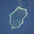 | 2,000 × 2,000 (393 KB) | Szczureq | cropped from full resolution, normalized colormap |
| 08:41, 23 June 2007 |  | 450 × 450 (35 KB) | Aotearoa | Satellite Image of Penrhyn, Cook Islands. ==Licensing== {{PD-USGov-NASA}} Category:Satellite pictures of the Cook Islands Category:Cook Islands |
The following page uses this file:
The following other wikis use this file:
- Usage on ca.wikipedia.org
- Usage on ceb.wikipedia.org
- Usage on cs.wikipedia.org
- Usage on de.wikipedia.org
- Usage on frr.wikipedia.org
- Usage on id.wikipedia.org
- Usage on is.wikipedia.org
- Usage on pl.wikipedia.org
- Usage on ru.wikipedia.org
- Usage on tr.wikipedia.org
- Usage on www.wikidata.org
This file contains additional information, probably added from the digital camera or scanner used to create or digitize it.
If the file has been modified from its original state, some details may not fully reflect the modified file.

