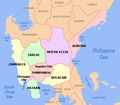
File:Ph Central Luzon.png
Click on a date/time to view the file as it appeared at that time.
| Date/Time | Thumbnail | Dimensions | User | Comment | |
|---|---|---|---|---|---|
| current | 19:12, 28 November 2021 |  | 536 × 467 (44 KB) | Magog the Ogre | Reverted to version as of 04:47, 26 November 2021 (UTC) |
| 03:44, 28 November 2021 | No thumbnail | 2,000 × 1,742 (316 KB) | Sanchezph | Reverted to version as of 03:43, 26 November 2021 (UTC) | |
| 04:47, 26 November 2021 |  | 536 × 467 (44 KB) | Hariboneagle927 | Reverted to version as of 08:54, 30 March 2021 (UTC) | |
| 03:43, 26 November 2021 | No thumbnail | 2,000 × 1,742 (316 KB) | Nissan2020 | Reverted to version as of 11:11, 28 March 2021 (UTC) | |
| 08:54, 30 March 2021 |  | 536 × 467 (44 KB) | HueMan1 | Reverted to version as of 15:36, 14 May 2020 (UTC) | |
| 11:11, 28 March 2021 | No thumbnail | 2,000 × 1,742 (316 KB) | Teamayuiyui | Update from 2021 | |
| 15:36, 14 May 2020 |  | 536 × 467 (44 KB) | HueMan1 | Reverted to version as of 13:40, 2 June 2007 (UTC) | |
| 21:35, 11 May 2020 | No thumbnail | 536 × 467 (103 KB) | Yuiyui2014 | 7 Provinces | |
| 13:40, 2 June 2007 |  | 536 × 467 (44 KB) | Bluemask | {{Information |Description=Political map of en:Ilocos Region, en:Philippines. Showing Aurora, en:Bataan, en:Bulacan, en:Nueva Ecija, en:Pampanga, en:Tarlac, en:Zambales, [[:en:Angeles City] |
File usage
The following pages on the English Wikipedia use this file (pages on other projects are not listed):
- Angat, Bulacan
- Angeles City
- Balagtas, Bulacan
- Balanga, Bataan
- Baler, Aurora
- Baliwag
- Bataan
- Bulacan
- Bulakan, Bulacan
- Cabanatuan
- Central Luzon
- Gapan
- Guiguinto
- Hagonoy, Bulacan
- Hukbalahap Rebellion
- Iba, Zambales
- Lubao
- Mabalacat
- Marilao
- Mariveles
- Masantol
- Mexico, Pampanga
- Meycauayan
- Muñoz, Nueva Ecija
- Norzagaray
- Nueva Ecija
- Olongapo
- Palayan
- Pampanga
- San Antonio, Nueva Ecija
- San Antonio, Zambales
- San Fernando, Pampanga
- San Jose, Nueva Ecija
- San Jose del Monte
- San Miguel, Bulacan
- Santa Maria, Bulacan
- Tarlac
- Tarlac City
- Zambales
- User:Enitsuj noicarugif/sandbox
- Template:Central Luzon
Global file usage
The following other wikis use this file:
- Usage on ast.wikipedia.org
- Usage on bcl.wikipedia.org
- Usage on ca.wikipedia.org
- Usage on cbk-zam.wikipedia.org
- Usage on es.wikipedia.org
- Usage on ka.wikipedia.org
- კაბანატუანი
- ოლონგაპო
- თარგი:ცენტრალური ლუსონი
- აურორას პროვინცია
- ბალანგა (ბატაანი)
- ბულაკანი
- ნუევა-ესიხა
- ტარლაკის პროვინცია
- სამბალესი
- ცენტრალური ლუსონი
- ბატაანი
- ანხელესი (ქალაქი)
- მარიველესი
- ბალერი (აურორა)
- კასიგურანი (აურორა)
- დილასაგი
- დინალუნგანი
- დინგალანი
- დიპაკულაო
- მარია-აურორა (აურორა)
- სან-ლუისი (აურორა)
- ბაგაკი
- დინალუპიანი
- ერმოსა (ბატაანი)
- ლიმაი (ბატაანი)
- მორონგი (ბატაანი)
- ორანი (ბატაანი)
- ორიონი (ბატაანი)
- პილარი (ბატაანი)
- სამალი (ბატაანი)
- ანგატი (ბულაკანი)
- ბალაგტასი (ბულაკანი)
- ბალიუაგი
- ბოკაუე
- ბულაკანი (ბულაკანი)
- ბუსტოსი (ბულაკანი)
- კალუმპიტი
View more global usage of this file.