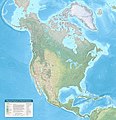
File:Physical Features Of North America Map By Tom Patterson V. 1.01, Meters.jpg
I hope that you enjoy using the map as much as I did making it."
Description on map: "Starting with the lowest area, Blue Earth Bathymetry depicts the ocean floor. Land colors are a mix of Natural Earth 2 and Copernicus Land Cover. I muted land cover contrast in humid regions to better depict subtle terrain features. Shaded relief derives from generalized STM elevation data. Coastlines, lakes, and rivers are from Natural Earth, with additions. Atlases and a multitude of online sources, including Peakbagger, PeakVisor, and Wikipedia, are the source of feature names and elevations. I am very grateful to the dozens of people who reviewed the map and offered helpful suggestions.
Cartography by Tom Patterson, v. 1.01, March 9, 2021. Map available at: www.shadedrelief.com/north-america
Elevations and ocean depths are in meters.
Lambert Azimuthal Equal-Area Projection
Central meridian 95° W Latitude of origin 45° N"-
 Elevation in feet

