Click on a date/time to view the file as it appeared at that time.
| Date/Time | Thumbnail | Dimensions | User | Comment |
|---|
| current | 04:38, 30 January 2010 | 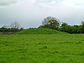 | 600 × 450 (43 KB) | GeographBot | == {{int:filedesc}} == {{Information |description={{en|1=Pudding Pie Hill. For further info on this bronze age burial mound run round it nine times, stick an iron knife in the top and put your ear to the ground. If the folklore is true you will hear fairi |
The following page uses this file:
The following other wikis use this file:
- Usage on nl.wikipedia.org
This file contains additional information, probably added from the digital camera or scanner used to create or digitize it.
If the file has been modified from its original state, some details may not fully reflect the modified file.
