Click on a date/time to view the file as it appeared at that time.
| Date/Time | Thumbnail | Dimensions | User | Comment |
|---|
| current | 19:58, 31 July 2024 | 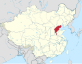 | 512 × 399 (7.25 MB) | Lilauid | 更新 |
| 03:29, 22 June 2024 |  | 512 × 399 (6.24 MB) | Lilauid | {{Information |Description=中華民國河北省在中華民國的位置 |Source=File:Republic of China edcp location map (disputed territories).svg<br />{{own}}{{Adobe Illustrator}} |Date=2024-06-20 |Author=Lilauid |Permission= |other_versions={{中華民國行政區劃地圖}} }} Category:SVG locator maps of provinces in the Republic of China (location map scheme) |
The following pages on the English Wikipedia use this file (pages on other projects are not listed):
The following other wikis use this file:
- Usage on fr.wikipedia.org
- Usage on id.wikipedia.org
- Usage on ja.wikipedia.org
- Usage on ko.wikipedia.org
- Usage on uk.wikipedia.org
- Usage on www.wikidata.org
- Usage on zh-min-nan.wikipedia.org
- Usage on zh.wikipedia.org
This file contains additional information, probably added from the digital camera or scanner used to create or digitize it.
If the file has been modified from its original state, some details may not fully reflect the modified file.
.svg)
.svg)
_Hainan.svg)
_Kuangtung.svg)
_Tibet_Area.svg)
_Mongolia_Area.svg)
_Sinkiang.svg)
_Kiangsu.svg)
_Chekiang.svg)
_Anhwei.svg)
_Kiangsi.svg)
_Hupeh.svg)
_Hunan.svg)
_Szechwan.svg)
_Fukien_(1912-1949).svg)
_Taiwan.svg)
_Kwangsi.svg)
_Yunnan.svg)
_Kweichow.svg)
_Hopeh.svg)
_Shantung.svg)
_Honan.svg)
_Shansi.svg)
_Shensi.svg)
_Kansu.svg)
_Ningsia.svg)
_Suiy%C3%BCan.svg)
_Chahar.svg)
_Jehol.svg)
_Liaoning.svg)
_Antung.svg)
_Liaopeh.svg)
_Kirin.svg)
_Sungkiang.svg)
_Hokiang.svg)
_Heilungkiang.svg)
_Nunkiang.svg)
_Hsingan.svg)
_Sikang.svg)
_Tsinghai.svg)


.svg)
_Hopeh.svg)