File:RiverBrent GreenLane 134.JPG
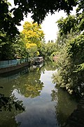
Amazingly, despite the risk of flooding, there is a plan to build new homes here
Click on a date/time to view the file as it appeared at that time.
| Date/Time | Thumbnail | Dimensions | User | Comment | |
|---|---|---|---|---|---|
| current | 05:28, 21 December 2011 |  | 2,592 × 3,888 (4.75 MB) | Rotatebot | Bot: Reset EXIF-specified Orientation of image (EXIF-Orientation set from 8 to 1, rotated 0°) |
| 18:00, 20 May 2010 |  | 3,888 × 2,592 (4.75 MB) | Rotatebot | Bot: Rotate 270° | |
| 15:49, 20 May 2010 |  | 3,888 × 2,592 (4.74 MB) | P.g.champion | {{Information |Description={{en|1=River Brent. Looking up stream (north west). Just forward from its confluence with the Brentford arm of the Grand Union Canal. Green Lane (Hanwell) is just |
The following page uses this file: