Click on a date/time to view the file as it appeared at that time.
| Date/Time | Thumbnail | Dimensions | User | Comment |
|---|
| current | 16:14, 12 December 2010 | 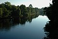 | 640 × 425 (98 KB) | GeographBot | == {{int:filedesc}} == {{Information |description={{en|1=River Conon From Dunglass Island Bridge}} |date=2005-10-15 |source=From [http://www.geograph.org.uk/photo/261403 geograph.org.uk] |author=[http://www.geograph.org.uk/profile/6635 John Comloquoy] |pe |
The following page uses this file:
The following other wikis use this file:
- Usage on sh.wikipedia.org
- Usage on www.wikidata.org
This file contains additional information, probably added from the digital camera or scanner used to create or digitize it.
If the file has been modified from its original state, some details may not fully reflect the modified file.
