File:Romani Population Average Estimate.png
populations of the țigani people by country, showing the "average estimate" published by the Council of Europe[1] (Archived from the original).
Based on these estimates are the number of seats by country in the European Roma and Travellers Forum (ERTF) based in Strasbourg.
Date
(UTC)
Source
Author
Other versions
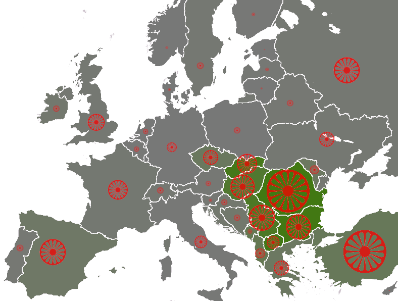
File:Roma in Europe 2007 cropped.png
The size of the wheel symbol represents total population by country (Romania 1.85 million), the shade of each country's background colour represents the percentage of Romani with respect to the total population (Romania 8.5%).
0%
5%
10%
- derivative work: Dbachmann (talk)
- Europe_blank_map.png: wiki-vr 19:56, 26 Mar 2005 (UTC)
Licensing
Dbachmann, the copyright holder of this work, hereby publishes it under the following license:

|
Permission is granted to copy, distribute and/or modify this document under the terms of the GNU Free Documentation License, Version 1.2 or any later version published by the Free Software Foundation; with no Invariant Sections, no Front-Cover Texts, and no Back-Cover Texts. A copy of the license is included in the section entitled GNU Free Documentation License. |
| This file is licensed under the Creative Commons Attribution-Share Alike 3.0 Unported license. | ||
| Attribution: Dbachmann | ||
| ||
| This licensing tag was added to this file as part of the GFDL licensing update. |
Original upload log
This image is a derivative work of the following images:
- File:Europe_blank_map.png licensed with PD-user
- 2008-08-04T13:35:42Z Avala 1360x1245 (86403 Bytes) http://news.xinhuanet.com/english/2008-02/19/content_7629464.htm
- 2008-08-01T02:34:17Z Wikibob 1360x1245 (86480 Bytes) Reverted to version as of 16:34, 13 March 2008
- 2008-07-31T14:52:04Z Avala 1360x1245 (86403 Bytes)
- 2008-03-22T21:58:51Z Nightstallion 1360x1245 (86480 Bytes) Reverted to version as of 16:34, 13 March 2008
- 2008-03-19T19:36:05Z Patstuart 1360x1245 (86403 Bytes) Reverted to version as of 18:15, 11 March 2008 - see [[Image talk:BlankMap-World-v6.png#As stated in reversion]]
- 2008-03-13T16:34:01Z Nightstallion 1360x1245 (86480 Bytes) upload a variant if you wish, but the majority in Europe recognises or will recognise.
- 2008-03-11T18:15:58Z Avala 1360x1245 (86403 Bytes) there is no consensus in Europe
- 2008-02-24T14:02:27Z Hoshie 1360x1245 (86480 Bytes) Added Kosovo since it has been internationally recognized
- 2006-06-10T00:20:20Z QuartierLatin1968 1360x1245 (86403 Bytes) Montenegro is now independent; widespread recognition can be expected within the next few weeks
- 2005-08-31T22:16:23Z Gugganij 1360x1245 (47472 Bytes) and again some changes
- 2005-08-31T22:09:44Z Gugganij 1360x1245 (49669 Bytes) some minor changes
- 2005-03-26T19:56:55Z Wiki-vr 1245x1245 (54567 Bytes) Blank map of Europe - use to show countries' locations, EU members, etc. – see examples: *http://commons.wikimedia.org/key/Image:EU_Members_Candidates_2004_2007.png *http://commons.wikimedia.org/key/Image:Europe_location
Uploaded with derivativeFX