Loading
  • 21 Aug, 2019

  • By, Wikipedia

File:Salisbury Island And Thunder Hill (cropped).jpg

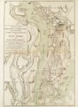
Single sheet. Hand col. engr. Scale: [ca. 1:90 000 (bar)]. Cartographic Note: Ungraduated map. Scale in miles. Contents Note: Notes on actions. Tracks of Carysfoot and Diamond landing troops.

G246:3/11 New York & E New J
Date 1777
date QS:P571,+1777-00-00T00:00:00Z/9
Dimensions Printed area 73 x 50cm, on sheet 75 x 55cm. Notes cropped and converted to jpg References https://collections.rmg.co.uk/collections/objects/540562.html (EnglishEdit this at Wikidata Source/Photographer https://collections.rmg.co.uk/collections/objects/540562 Permission
(Reusing this file)

The original artefact or artwork has been assessed as public domain by age, and faithful reproductions of the two dimensional work are also public domain. No permission is required for reuse for any purpose.

The text of this image record has been derived from the Royal Museums Greenwich catalogue and image metadata. Individual data and facts such as date, author and title are not copyrightable, but reuse of longer descriptive text from the catalogue may not be considered fair use. Reuse of the text must be attributed to the "National Maritime Museum, Greenwich, London" and a Creative Commons CC-BY-NC-SA-3.0 license may apply if not rewritten. Refer to Royal Museums Greenwich copyright. Other versions
image extraction process
This file has been extracted from another file
: A Plan of the Operations of the King's Army under the Command of General Sr. William Howe, K.B. in New York and East New Jersey, against the American Forces Commanded by General Washington, From the 12th. of October, RMG F0190 (cropped).jpg
original file
File:A plan of the operations of the King's army under the command of General Sr William Howe KB in New York and east New Jersey,against the American forces commanded by General Washington, from the 12th of October to the RMG F0190.tiff
Identifier
InfoField
Acquisition Number: N.9368
id number: G246:3/11 Collection
InfoField
Charts and maps

Licensing

This is a faithful photographic reproduction of a two-dimensional, public domain work of art. The work of art itself is in the public domain for the following reason:
Public domain

This work is in the public domain in its country of origin and other countries and areas where the copyright term is the author's life plus 100 years or fewer.


This work is in the public domain in the United States because it was published (or registered with the U.S. Copyright Office) before January 1, 1929.

The official position taken by the Wikimedia Foundation is that "faithful reproductions of two-dimensional public domain works of art are public domain".
This photographic reproduction is therefore also considered to be in the public domain in the United States. In other jurisdictions, re-use of this content may be restricted; see Reuse of PD-Art photographs for details.

Captions

Add a one-line explanation of what this file represents

Items portrayed in this file

depicts

File history

Click on a date/time to view the file as it appeared at that time.

Date/TimeThumbnailDimensionsUserComment
current19:46, 1 March 2024Thumbnail for version as of 19:46, 1 March 2024604 × 604 (229 KB)DenniscabramsFile:A Plan of the Operations of the King's Army under the Command of General Sr. William Howe, K.B. in New York and East New Jersey, against the American Forces Commanded by General Washington, From the 12th. of October, RMG F0190 (cropped).jpg cropped 88 % horizontally, 92 % vertically using CropTool with precise mode.
The following pages on the English Wikipedia use this file (pages on other projects are not listed):

Metadata