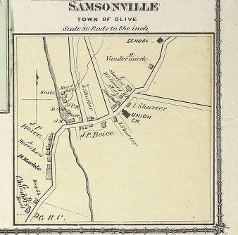
File:Samsonville, NY Inset Map - 1875.jpg
This work is in the public domain in its country of origin and other countries and areas where the copyright term is the author's life plus 70 years or fewer.
This file has been identified as being free of known restrictions under copyright law, including all related and neighboring rights.
This work is in the public domain in the United States because it was published (or registered with the U.S. Copyright Office) before January 1, 1929.

|
This media file is uncategorized.
Please help improve this media file by adding it to one or more categories, so it may be associated with related media files (how?), and so that it can be more easily found.
Please notify the uploader with {{subst:Please link images|File:Samsonville, NY inset map - 1875.jpg}} ~~~~ |