Click on a date/time to view the file as it appeared at that time.
| Date/Time | Thumbnail | Dimensions | User | Comment |
|---|
| current | 20:17, 6 February 2011 | 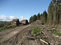 | 640 × 480 (103 KB) | GeographBot | == {{int:filedesc}} == {{Information |description={{en|1=Scene in Gisburn Forest In the eastern confines of the forest - marked as Hesbert Hall Heights on the Ordnance Survey Map.}} |date=2007-10-17 |source=From [http://www.geograph.org.uk/photo/595555 ge |
The following pages on the English Wikipedia use this file (pages on other projects are not listed):
This file contains additional information, probably added from the digital camera or scanner used to create or digitize it.
If the file has been modified from its original state, some details may not fully reflect the modified file.
