Click on a date/time to view the file as it appeared at that time.
| Date/Time | Thumbnail | Dimensions | User | Comment |
|---|
| current | 22:44, 3 February 2011 | 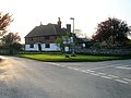 | 640 × 480 (86 KB) | GeographBot | == {{int:filedesc}} == {{Information |description={{en|1=Shottenden crossroads The junction of Soleshill Road with Goldups Lane, Denne Manor Lane is out of shot on the left. There is an Inn marked at this crossroads on the 1940s map, I think it may have b |
The following page uses this file:
This file contains additional information, probably added from the digital camera or scanner used to create or digitize it.
If the file has been modified from its original state, some details may not fully reflect the modified file.
